
File:Ghana regions named.png
Ghana_regions_named.png (250 × 352 pixels, file size: 11 KB, MIME type: image/png)
| |
This is a file from the Wikimedia Commons. Information from its description page there is shown below.
Commons is a freely licensed media file repository. You can help. |
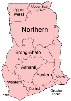
| Description | Map of the regions of Ghana, named in English (native language). The individual maps are:
|
| Date | June 2005 |
| Source | Self-made, traced from public domain UN or CIA maps. |
| Author | User:Golbez |
| Permission ( Reusing this file) |
Provide attribution, please. See below. |
|

File usage
The following pages on Schools Wikipedia link to this image (list may be incomplete):
Background information
Schools Wikipedia was created by children's charity SOS Children's Villages. SOS Children's Villages believes that a decent childhood is essential to a happy, healthy. Our community work brings families new opportunities through education, healthcare and all manner of support. Will you help another child today?