
File:Guyane map-en.svg
| |
This is a file from the Wikimedia Commons. Information from its description page there is shown below.
Commons is a freely licensed media file repository. You can help. |
Summary
| Description |
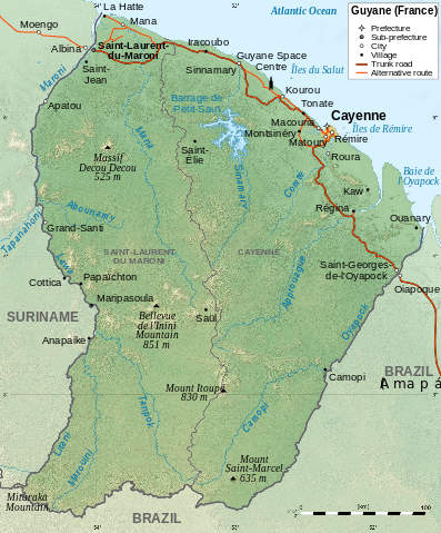
English: Map of French Guiana.
Français : Carte de la Guyane.
|
| Date | 28 January 2009 |
| Source | travail personnel (own work). Sources :
|
| Author | Sémhur, RaviC (translation) |
|
Camera location |
|
This and other images at their locations on: Google Maps - Google Earth - OpenStreetMap | ( Info) |
|---|
This map was improved or created by the Wikigraphists of the Graphic Lab (fr). You can propose images to clean up, improve, create or translate as well.
বাংলা | català | česky | Deutsch | Deutsch (Sie-Form) | Ελληνικά | English | Esperanto | español | suomi | français | עברית | magyar | Հայերեն | italiano | 한국어 | македонски | Bahasa Melayu | Plattdüütsch | Nederlands | occitan | polski | português | română | русский | slovenščina | svenska | татарча/tatarça | Türkçe | українська | 中文 | 中文(简体) | 中文(繁體) | Zazaki | +/−
| |
This SVG file uses embedded text that can be easily translated into your language using this automated tool. Learn more. You can also download it and translate it manually using a text editor. العربية | беларуская (тарашкевіца) | bosanski | català | česky | dansk | Deutsch | Ελληνικά | English | Esperanto | español | eesti | فارسی | suomi | français | galego | עברית | hrvatski | magyar | Հայերեն | italiano | 日本語 | ქართული | ភាសាខ្មែរ | 한국어 | lietuvių | македонски | മലയാളം | Bahasa Melayu | Plattdüütsch | Nederlands | norsk nynorsk | norsk bokmål | polski | português | русский | slovenščina | shqip | српски / srpski | svenska | ไทย | Türkçe | татарча/tatarça | українська | Tiếng Việt | Volapük | 中文 | 中文(简体) | +/- |
|
|
This vector image was created with Inkscape. |
Licensing
|

File usage
Metadata
About Schools Wikipedia
Through Schools Wikipedia, SOS Childrens Villages has brought learning to children around the world. SOS Childrens Villages is a global charity founded in 1949 to give children who have lost everything the childhood they deserve. We have helped children in Africa for many years - you can help too...