
File:ZimbabweOMC.png
Size of this preview: 579 × 480 pixels.
| |
This is a file from the Wikimedia Commons. Information from its description page there is shown below.
Commons is a freely licensed media file repository. You can help. |
| Description |
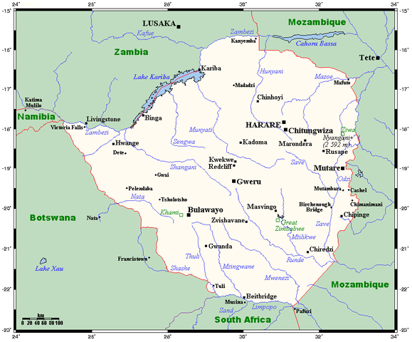
English: A map showing Zimbabwe's cities, main towns, selected villages, rivers, selected archaeological sites and its highest peak. This map's source is here, with the uploader's modifications, and the GMT homepage says that the tools are released under the GNU General Public License.
|
| Date | 17 July 2008 (original upload date) |
| Source | Transferred from en.wikipedia |
| Author | Original uploader was Kelisi at en.wikipedia |
| Permission ( Reusing this file) |
CC-BY-SA-3.0-MIGRATED; Released under the GNU Free Documentation License. |
Licensing
| This file is licensed under the Creative Commons Attribution-Share Alike 3.0 Unported license. | ||
|
||
| This licensing tag was added to this file as part of the GFDL licensing update.
|
|

File usage
The following pages on Schools Wikipedia link to this image (list may be incomplete):
Metadata
Schools Wikipedia facts
Through Schools Wikipedia, SOS Children's Villages has brought learning to children around the world. SOS Childrens Villages works in 133 countries and territories across the globe, helps more than 62,000 children, and reaches over 2 million people in total. Why not try to learn more about child sponsorship?