
File:Sf-map.png
Sf-map.png (327 × 350 pixels, file size: 10 KB, MIME type: image/png)
| |
This is a file from the Wikimedia Commons. Information from its description page there is shown below.
Commons is a freely licensed media file repository. You can help. |
 |
File:Map of South Africa.svg is a vector version of this file. It should be used in place of this raster image when superior. File:Sf-map.png
For more information about vector graphics, read about Commons transition to SVG.
|
 |
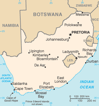
Afrikaans: 'n Eenvoudige kaart van Suid-Afrika, uitgegee deur die Amerikaanse organisasie, die CIA.
English: CIA map of South Africa
 |
This image is in the public domain because it contains materials that originally came from the United States Central Intelligence Agency's World Factbook.
|
 |
derivative works
Derivative works of this file:
File usage
The following pages on Schools Wikipedia link to this image (list may be incomplete):
The best way to learn
Wikipedia for Schools was collected by SOS Childrens Villages. Thanks to SOS Children, 62,000 children are enjoying a happy childhood, with a healthy, prosperous future ahead of them. Help another child by taking out a sponsorship.