
File:MozambiqueOMC.png
Size of this preview: 336 × 479 pixels.
| |
This is a file from the Wikimedia Commons. Information from its description page there is shown below.
Commons is a freely licensed media file repository. You can help. |
Summary
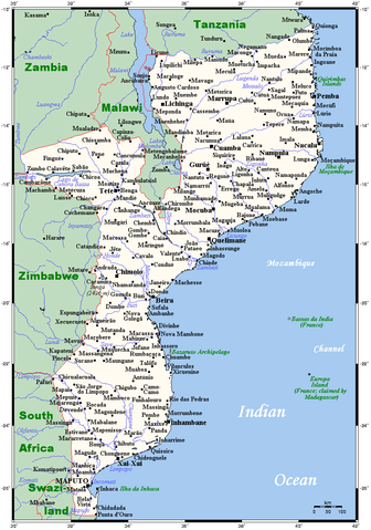
| Description | A map showing Mozambique's cities, main towns, selected villages, rivers and its highest peak. |
| Date | 12 August 2007 |
| Source | aquarius.ifm-geomar.de, with modifications by en:User:Kelisi. According to the GMT homepage the tools are released under the GNU General Public License. |
| Author | GMT (The Generic Mapping Tools), modifications by en:User:Kelisi |
Licensing
| |
The map has been created with the Generic Mapping Tools: http://gmt.soest.hawaii.edu/ using one or more of these public domain datasets for the relief:
|
 |
Permission is granted to copy, distribute and/or modify this document under the terms of the GNU Free Documentation License, Version 1.2 or any later version published by the Free Software Foundation; with no Invariant Sections, no Front-Cover Texts, and no Back-Cover Texts. A copy of the license is included in the section entitled GNU Free Documentation License.
|
| This file is licensed under the Creative Commons Attribution-Share Alike 3.0 Unported license. | ||
|
||
| This licensing tag was added to this file as part of the GFDL licensing update.
|
File usage
The following pages on Schools Wikipedia link to this image (list may be incomplete):
About Schools Wikipedia
SOS Childrens Villages has brought Wikipedia to the classroom. In 133 nations around the world, SOS Childrens Villages works to bring better education and healthcare to families in desperate need of support. Will you help another child today?