
File:Chad Topography.png
Size of this preview: 318 × 480 pixels.
| |
This is a file from the Wikimedia Commons. Information from its description page there is shown below.
Commons is a freely licensed media file repository. You can help. |
Summary
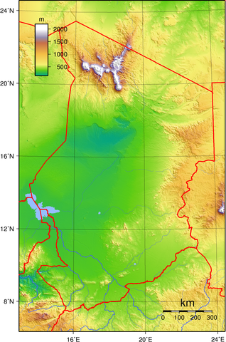
| Description | Topographic map of Chad. Created with GMT from GLOBE data. |
| Date | 14 June 2007 |
| Source | Own work |
| Author | Sadalmelik |
Licensing
 |
This work has been released into the public domain by its author, I, Sadalmelik. This applies worldwide. In some countries this may not be legally possible; if so: I, Sadalmelik grants anyone the right to use this work for any purpose, without any conditions, unless such conditions are required by law.
|
File usage
The following pages on Schools Wikipedia link to this image (list may be incomplete):
What is Schools Wikipedia?
Through Schools Wikipedia, SOS Childrens Villages has brought learning to children around the world. SOS Children helps those who have nothing and no one, giving them back the famly they have lost and bringing them the very best opportunities for a happy, healthy future. Sponsoring a child is the coolest way to help.