
File:Gettysburg Battle Map Day1.png
Size of this preview: 330 × 479 pixels.
| |
This is a file from the Wikimedia Commons. Information from its description page there is shown below.
Commons is a freely licensed media file repository. You can help. |
Legend: (cur) = this is the current file, (del) = delete this old version, (rev) = revert to this old version. Click on date to download the file or see the image uploaded on that date.
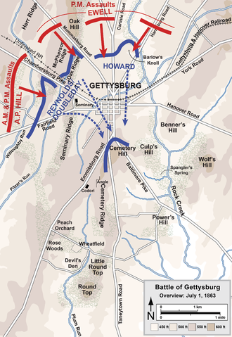
- (del) (cur) 03:18, 29 March 2006 . . Hlj (Talk | contribs) . . 1537x2350 (1,070,374 bytes) (Overview map of the Battle of Gettysburg, July 1 1863. Drawn by Hal Jespersen in Adobe Illustrator CS5. Graphic source file is available at http://www.posix.com/CWmaps/
| This file is licensed under the Creative Commons Attribution 3.0 Unported license. | ||
| Attribution: Map by Hal Jespersen, www.posix.com/CW | ||
|
File usage
The following pages on Schools Wikipedia link to this image (list may be incomplete):
About Schools Wikipedia
This selection has made Wikipedia available to all children. SOS Children's Villages helps more than 2 million people across 133 countries around the world. There are many ways to help with SOS Children's Villages.