
File:EisrandlagenNorddeutschland.png
EisrandlagenNorddeutschland.png (474 × 405 pixels, file size: 349 KB, MIME type: image/png)
| |
This is a file from the Wikimedia Commons. Information from its description page there is shown below.
Commons is a freely licensed media file repository. You can help. |
Summary
| Description |
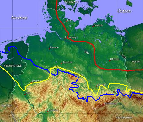
English: Ice age map of europe, red: maximum limit of Weichselian ice age, yellow Saale-ice age at maximum (Drenthe stage), blue Elster-ice age maximum glaciation.
Deutsch:
|
| Date | 25 July 2006 (original upload date) |
| Source | Originally from de.wikipedia; description page is/was here. |
| Author | Original uploader was Botaurus at de.wikipedia |
Licensing
 |
This work has been released into the public domain by its author, Botaurus at the wikipedia project. This applies worldwide. In case this is not legally possible: |
File usage
The following pages on Schools Wikipedia link to this image (list may be incomplete):
Schools Wikipedia facts
SOS Children chose the best bits of Wikipedia to help you learn. SOS Children believes that a decent childhood is essential to a happy, healthy. Our community work brings families new opportunities through education, healthcare and all manner of support. Sponsoring a child is the coolest way to help.