
File:Bridgetown2.jpg
| |
This is a file from the Wikimedia Commons. Information from its description page there is shown below.
Commons is a freely licensed media file repository. You can help. |
Summary
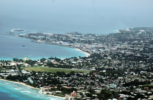
Bridgetown, Barbados, selfmade photograph on Nov 10 2005
Facing west-north-west: The scene features the Greater Bridgetown Area and it's immediate environs. The picture is overlooking the south-western edge of the Parish of Christ Church, as well as portions of the southern coastline of Barbados. The photo includes the Deep Water Harbour located in the upper-left most portions of the photo. The 150-acre Garrison Savannah (horse-track) is featured almost centrally. To the right of the Garrison, some distance away towards the centre of Bridgetown can be observed the taller Central Bank of Barbados building rising above all surrounding buildings.
Licensing
 |
Permission is granted to copy, distribute and/or modify this document under the terms of the GNU Free Documentation License, Version 1.2 or any later version published by the Free Software Foundation; with no Invariant Sections, no Front-Cover Texts, and no Back-Cover Texts. A copy of the license is included in the section entitled GNU Free Documentation License.
|
| This file is licensed under the Creative Commons Attribution-Share Alike 3.0 Unported license. | ||
|
||
| This licensing tag was added to this file as part of the GFDL licensing update.
|
File usage
A background to Schools Wikipedia
SOS Childrens Villages chose the best bits of Wikipedia to help you learn. SOS Children believes that a decent childhood is essential to a happy, healthy. Our community work brings families new opportunities through education, healthcare and all manner of support. Try to find out how you can help children in other countries on our web site.