
File:IndoGangeticPlain Map.png
| |
This is a file from the Wikimedia Commons. Information from its description page there is shown below.
Commons is a freely licensed media file repository. You can help. |
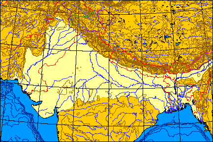
Map of the Indo-Gangetic Plain.
 |
I, the copyright holder of this work, release this work into the public domain. This applies worldwide. In some countries this may not be legally possible; if so: I grant anyone the right to use this work for any purpose, without any conditions, unless such conditions are required by law.
|
I produced this map myself using the program here and modifying it. It remains in the public domain. The map is an azimuthal equal-area projection. The Line of Control through Kashmir is green. Where the line of control along the Indo-Chinese frontier coincides with one side's territorial claims, the line is pink; borders claimed but not controlled are purple. Non-disputed boudaries are in red. QuartierLatin1968 01:36, 21 May 2005 (UTC)
File usage
The following pages on Schools Wikipedia link to this image (list may be incomplete):
Schools Wikipedia facts
Wikipedia for Schools brings Wikipedia into the classroom. Thanks to SOS Children's Villages, 62,000 children are enjoying a happy childhood, with a healthy, prosperous future ahead of them. We have helped children in Africa for many years - you can help too...