
File:Howland island nasa.jpg
| |
This is a file from the Wikimedia Commons. Information from its description page there is shown below.
Commons is a freely licensed media file repository. You can help. |
Summary
| Description |
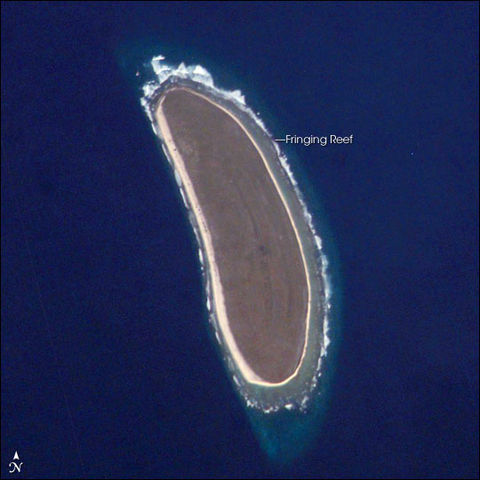
Deutsch: NASA-Astronautenbild der Howlandsinsel im Pazifischen Ozean
English: NASA astronaut image of Howland Island in the Pacific Ocean
|
||||||||||||||||||||||||||||||||||||||||||||||||||||||
| Date | 4 April 2007 | ||||||||||||||||||||||||||||||||||||||||||||||||||||||
| Source | http://earthobservatory.nasa.gov/Newsroom/NewImages/Images/ISS010-E-9287_lrg.jpg | ||||||||||||||||||||||||||||||||||||||||||||||||||||||
| Author | NASA | ||||||||||||||||||||||||||||||||||||||||||||||||||||||
| Permission ( Reusing this file) |
Conditions of Use of Astronaut Photographs |
||||||||||||||||||||||||||||||||||||||||||||||||||||||
| This image or video was catalogued by Johnson Space Centre of the United States National Aeronautics and Space Administration (NASA) under Photo ID: ISS010-E-9287. This tag does not indicate the copyright status of the attached work. A normal copyright tag is still required. See Commons:Licensing for more information. |
Licensing
 |
This file is in the public domain because it was created by the Image Science & Analysis Laboratory, of the NASA Johnson Space Centre. NASA copyright policy states that "NASA material is not protected by copyright unless noted". ( NASA copyright policy page or Conditions of Use of Astronaut Photographs). Photo source: ISS010-E-9287.
|
File usage
The best way to learn
Schools Wikipedia has been carefully checked to give you the best learning experience. SOS Children is an international children's charity, providing a good home and loving family to thousands of children who have lost their parents. We also work with communities to help vulnerable families stay together and raise children in the best possible environment. Will you help another child today?