
File:Wolf distr.gif
Size of this preview: 640 × 190 pixels.
| |
This is a file from the Wikimedia Commons. Information from its description page there is shown below.
Commons is a freely licensed media file repository. You can help. |
Summary
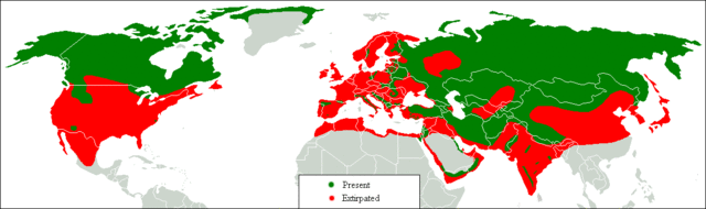
| Description |
English: Range map. Green, present; red, former.
|
| Date | 3 March 2007 |
| Source | Transferred from en.wikipedia;. |
| Author | Tommyknocker at en.wikipedia |
| Permission ( Reusing this file) |
Released into the public domain (by the author). |
 |
This map image could be recreated using vector graphics as an SVG file. This has several advantages; see Commons:Media for cleanup for more information. If an SVG form of this image is already available, please upload it. After uploading an SVG, replace this template with {{ vector version available|new image name.svg}}. |
Licensing
 |
This work has been released into the public domain by its author, Tommyknocker at the wikipedia project. This applies worldwide. In case this is not legally possible: |
File usage
The following pages on Schools Wikipedia link to this image (list may be incomplete):
Schools Wikipedia and SOS Children
SOS Children's Villages chose the best bits of Wikipedia to help you learn. Thanks to SOS Children, 62,000 children are enjoying a happy childhood, with a healthy, prosperous future ahead of them. Will you help another child today?