
File:Gaza Strip map2.svg
Size of this preview: 391 × 479 pixels.
| |
This is a file from the Wikimedia Commons. Information from its description page there is shown below.
Commons is a freely licensed media file repository. You can help. |
Summary
| Description |
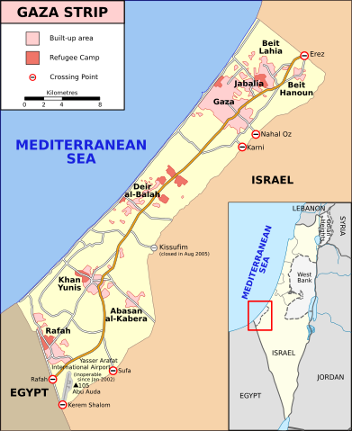
English: Map of Gaza Strip, Stand December 2008 (SVG version of File:Gaza Strip map.png by Lencer)
Français : Carte de la bande de Gaza (décembre 2008)
|
| Date | 9 January 2009 |
| Source | SVG version of File:Gaza_Strip_map.png, created using Inkscape v. 0.46. with help from GIMP 2.4.7.:
|
| Author | Gringer ( talk) 14:01, 8 January 2009 (UTC) |
Licensing
| This file is licensed under the Creative Commons Attribution-Share Alike 3.0 Unported license. | ||
|
File usage
The following pages on Schools Wikipedia link to this image (list may be incomplete):
Metadata
Learn more
Wikipedia for Schools was collected by SOS Childrens Villages. Our 500 Children's Villages provide a home for thousands of vulnerable children. Beyond our Villages, we support communities, helping local people establish better schools and delivering effective medical care to vulnerable children. Why not try to learn more about child sponsorship?