
File:England and Wales population cartogram districts.svg
- File
- File usage
- Metadata
- Find out about Schools Wikipedia
Size of this preview: 413 × 479 pixels.
| |
This is a file from the Wikimedia Commons. Information from its description page there is shown below.
Commons is a freely licensed media file repository. You can help. |
Summary
| Description |
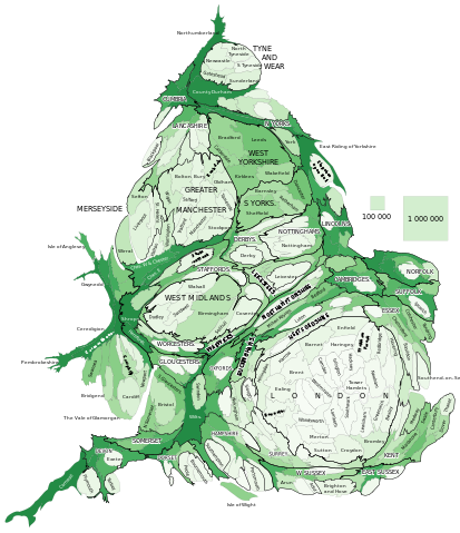
Polski: Kartogram ludności Anglii i Walii. Liczba ludności według jednostek administracyjnych. Ich wielkość jest w przybliżeniu proporcjonalna do liczby mieszkańców według danych z cenzusu z 2011. Im ciemniejszy kolor tym większa rzeczywista powierzchnia.
English: Population by administrative areas. Their size is approximately in proportion to their population according to 2011 Census data. The darker colour the bigger is the real area
|
| Date | 14 March 2013, 18:12:29 |
| Source | Own work |
| Author | PawełS |
Software: ScapeToad (First grid 1 600; Diffusion grid size 1024; 8 iterations)
| |
This image was created with Quantum GIS. |
Cartogram Creator plugin 10 iterations
Licensing
|
Metadata
Find out about Schools Wikipedia
SOS Childrens Villages has brought Wikipedia to the classroom. Our 500 Children's Villages provide a home for thousands of vulnerable children. Beyond our Villages, we support communities, helping local people establish better schools and delivering effective medical care to vulnerable children. There are many ways to help with SOS Childrens Villages.