
File:Kurdish-inhabited area by CIA (1992).jpg
| |
This is a file from the Wikimedia Commons. Information from its description page there is shown below.
Commons is a freely licensed media file repository. You can help. |
Summary
| Description |
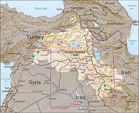
English: Kurdish-inhabited area, by CIA (1992)
Ελληνικά: Περιοχές κατοικούμενες από Κούρδους κατά τη CIA (1992)
|
| Date | August 1992 or earlier |
| Source | Perry-Castañeda Library Map Collection at The University of Texas at Austin http://www.lib.utexas.edu/maps/middle_east_and_asia/kurdish_lands_92.jpg linked from Perry-Castañeda Library Map Collection at The University of Texas at Austin |
| Author |
English: Source stated "The following maps were produced by the U.S. Central Intelligence Agency, unless otherwise indicated."
|
Please do not overwrite original files: any restoration work should be uploaded with a new name and linked in this page's "Other versions =" parameter, so that this file represents the exact file found in the CIA catalog record to which it links. The metadata on this page was imported directly from CIA's catalog record; additional descriptive text may be added by Wikimedians to the template below with the "descriptions =" parameter, but please do not modify the other fields. (Please note: this template is not yet part of an official guideline or policy)
Licensing
 |
This image is a work of a Central Intelligence Agency employee, taken or made as part of that person's official duties. As a Work of the United States Government, this image or media is in the public domain.
|
 |
See also
File usage
Want to know more?
SOS Children aims to make Wikipedia suitable for young learners. SOS Children's Villages works in 133 countries and territories across the globe, helps more than 62,000 children, and reaches over 2 million people in total. Have you thought about sponsoring a child?