 |
This is a file from the Wikimedia Commons. Information from its description page there is shown below.
Commons is a freely licensed media file repository. You can help.
|
| Description |
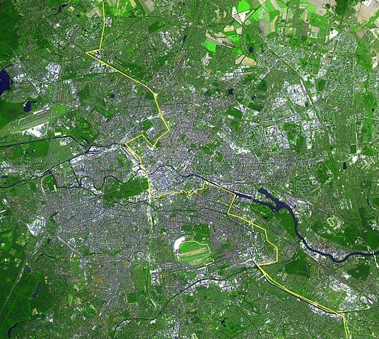
English: Satellite image of Berlin, Germany. The yellow line marks where the Berlin Wall once stood.
This simulated natural colour ASTER image covers an area of 22.5 by 20.2 km, and was acquired August 22, 2002.
Deutsch: Lage der Berliner Mauer auf einem Satellitenbild, Gut zu erkennen sind auf diesem Bild aus dem Jahre 2002 die Spree, welche sich horizontal durch die Stadt zieht und der gelb eingezeichnete ehemalige Grenzverlauf zwischen Ost und West. Auffällig sind weiterhin die dichte Bebauung der Berliner Innenstadt innerhalb des S-Bahnrings bzw. der Stadtautobahn, Flughafen Tegel im Nordwesten und Flughafen Tempelhof im Süden, der inmitten der Stadt liegende grüne Tiergarten mit Siegessäule, Messegelände, Tegeler See, Mitte, Spreebogen am Reichstagsgebäude, Lichtenberg, Marzahn und zwei Sportstadien im Osten, Hufeisensiedlung, Britzer Garten südlich des Flughafen Tempelhof...
Español: Situación del Muro de Berlín trazada sobre una fotografía tomada desde un satélite
Slovenčina: Fotografia múru zo satelitu
|
| Date |
English: August 22, 2002
|
| Source |
http://earthobservatory.nasa.gov/Newsroom/NewImages/images.php3?img_id=16417 |
| Author |
English: NASA/GSFC/MITI/ERSDAC/JAROS, and U.S./Japan ASTER Science Team
|
Permission
( Reusing this file) |
| Public domainPublic domainfalsefalse |
 |
This file is in the public domain because it was solely created by NASA. NASA copyright policy states that "NASA material is not protected by copyright unless noted". (See Template:PD-USGov, NASA copyright policy page or JPL Image Use Policy.) |
|
|
|
Warnings:
- Use of NASA logos, insignia and emblems are restricted per US law 14 CFR 1221.
- The NASA website hosts a large number of images from the Soviet/ Russian space agency, and other non-American space agencies. These are not necessarily in the public domain.
- Materials based on Hubble Space Telescope data may be copyrighted if they are not explicitly produced by the STScI. See also {{ PD-Hubble}} and {{ Cc-Hubble}}.
- The SOHO (ESA & NASA) joint project implies that all materials created by its probe are copyrighted and require permission for commercial non-educational use.
- Images featured on the Astronomy Picture of the Day (APOD) web site may be copyrighted.
|
|
File usage
The following pages on Schools Wikipedia link to this image (list may be incomplete):
SOS Childrens Villages chose the best bits of Wikipedia to help you learn. SOS Childrens Villages believes that a decent childhood is essential to a happy, healthy. Our community work brings families new opportunities through education, healthcare and all manner of support. Have you thought about sponsoring a child?


