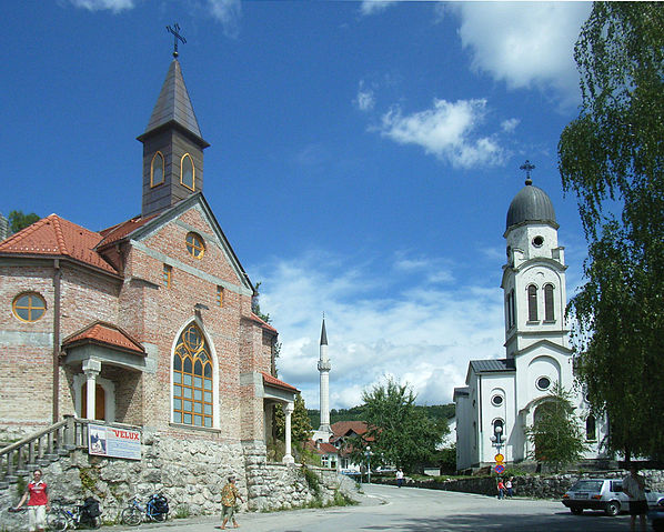
File:Bosanska Krupa Churches.JPG

Size of this preview: 598 × 479 pixels.
| |
This is a file from the Wikimedia Commons. Information from its description page there is shown below.
Commons is a freely licensed media file repository. You can help. |
Summary
| DescriptionBosanska Krupa Churches.JPG |
Hrvatski: Katolička crkva, džamija i srpska pravoslavna crkva u Bosanskoj Krupi
English: Catholic church, Mosque and Serbian Orthodox Church in Bosanska Krupa, Bosnia and Herzegovina
Română: O biserică catolică, una ortodoxă și o moschee în Bosanska Krupa ( Bosnia și Herțegovina)
Deutsch: Katholische Kirche, Moschee und Serbisch-Orthodoxe Kirche in Bosanska Krupa ( Bosnien und Herzegowina)
Nederlands: Een katholieke kerk, een moskee en een Servisch-orthodoxe kerk in Bosanska Krupa ( Bosnië en Herzegovina)
|
| Date | 12 August 2007 |
| Source | Own work |
| Author | Mazbln |
|
Camera location |
44° 53′ 3.72″ N, 16° 9′ 18.73″ E |
View this and other nearby images on: Google Maps - Google Earth - OpenStreetMap | ( Info)44.88436714;16.15520239 |
|---|
Licensing
|
File usage
The following pages on Schools Wikipedia link to this image (list may be incomplete):
Metadata
This file contains additional information, probably added from the digital camera or scanner used to create or digitize it. If the file has been modified from its original state, some details may not fully reflect the modified file.
| Camera manufacturer | RICOH |
|---|---|
| Camera model | Caplio R2 MS |
| Copyright holder | (C) by Caplio R2 User |
| Exposure time | 1/1,230 sec (0.0008130081300813) |
| F-number | f/5.4 |
| ISO speed rating | 100 |
| Date and time of data generation | 13:54, 12 August 2007 |
| Lens focal length | 4.6 mm |
| Latitude | 44° 53′ 3.72″ N |
| Longitude | 16° 9′ 18.73″ E |
| Altitude | 157.8 meters above sea level |
| Orientation | Normal |
| Horizontal resolution | 72 dpi |
| Vertical resolution | 72 dpi |
| Software used | Adobe Photoshop 7.0 |
| File change date and time | 13:40, 5 October 2011 |
| Y and C positioning | Co-sited |
| Exposure Program | Normal program |
| Exif version | 2.21 |
| Date and time of digitizing | 13:54, 12 August 2007 |
| Meaning of each component |
|
| Image compression mode | 1.6 |
| APEX aperture | 4.9 |
| APEX brightness | 10.7 |
| Exposure bias | 0 |
| Maximum land aperture | 3.3 APEX (f/3.14) |
| Metering mode | Pattern |
| Light source | Unknown |
| Flash | Flash did not fire, auto mode |
| Supported Flashpix version | 0,100 |
| Colour space | sRGB |
| Exposure mode | Auto exposure |
| White balance | Auto white balance |
| Scene capture type | Standard |
| Sharpness | Hard |
| GPS time (atomic clock) | 11:54 |
| Satellites used for measurement | 0 |
| Geodetic survey data used | WGS-84 |
| GPS date | 12 August 2007 |
| GPS tag version | 2.2.0.0 |
Learn more
Through Schools Wikipedia, SOS Children's Villages has brought learning to children around the world. More than 2 million people benefit from the global charity work of SOS Children, and our work in 133 countries around the world is vital to ensuring a better future for vulnerable children. Help another child by taking out a sponsorship.

