
File:Wacht am Rhein map (Opaque).svg
Size of this preview: 297 × 480 pixels.
| |
This is a file from the Wikimedia Commons. Information from its description page there is shown below.
Commons is a freely licensed media file repository. You can help. |
| |
This is a featured picture, which means that members of the community have identified it as one of the finest images on the English Wikipedia, adding significantly to its accompanying article. If you have a different image of similar quality, be sure to upload it using the proper free license tag, add it to a relevant article, and nominate it. |
|
Summary
| Description |
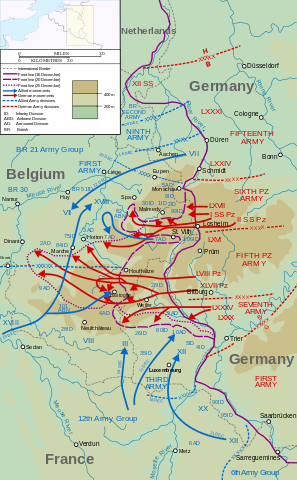
English: Map of the opening of the salient, the start of the Battle of the Bulge (German: Wacht am Rhein, "Watch on the Rhine"). Map covers 16 – 25 December 1944. Main source for map is File:P23(map).jpg, taken from http://www.history.army.mil/brochures/ardennes/aral.htm
The frontlines in the Monschau-Malmedy-Pruem area have been adjusted as shown in, for example, http://www.defense.gov/home/Specials/bulge/images/indexb_10a.jpg and File:Battle of the Bulge 6th.jpg. Français: Carte montrant le déplacement de troupes du 16 au 25 décembre 1944 lors de la bataille des Ardennes.
|
| Date | 06:09, 14 February 2012 (UTC) |
| Source | Map data, operation lines, etc. taken from File:P23(map).jpg, a US military source. Also incorporate elements from File:France_blank.svg ( User:Sting), File:Maps template-history patch-en.svg (Sting and User:Yug), File:P23(map).jpg (US Military), and File:Wacht am Rhein map.svg ( User:Grandiose) |
| Author | User:Matthewedwards |
Licensing
| This file is licensed under the Creative Commons Attribution-Share Alike 3.0 Unported license. | ||
|
File usage
The following pages on Schools Wikipedia link to this image (list may be incomplete):
Metadata
Schools Wikipedia and SOS Children
Schools Wikipedia was created by children's charity SOS Children. SOS Childrens Villages is a global charity founded in 1949 to give children who have lost everything the childhood they deserve. Will you help another child today?
Categories: