 |
This is a file from the Wikimedia Commons. Information from its description page there is shown below.
Commons is a freely licensed media file repository. You can help.
|
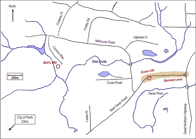
The is a map of the area in which Yagan died, located in the Perth, Western Australia suburb of Belhus. The map shows what is believed to be the approximate location of the grave, and the approximate area over which occurred the skirmish in which he was killed. The locations are taken from information provided by the Government of Western Australia's Department of Indigenous Affairs online Aboriginal Heritage Information System.
The map was hand-drawn by the uploader. This image replaced the lower quality image Image:Yagan-Belhus.jpg
 |
Open this image as an overlay in Google Earth ( Google Maps, Bing) |
( Help| Source) |
According to this map, the approximate location of Yagan's burial is 31°46′49.38″S 116°0′56.89″E / 31.7803833°S 116.0158028°E / -31.7803833; 116.0158028 - gobeirne 06:24, 26 June 2006 (UTC)
| Public domainPublic domainfalsefalse |
 |
I, the copyright holder of this work, release this work into the public domain. This applies worldwide.
In some countries this may not be legally possible; if so:
I grant anyone the right to use this work for any purpose, without any conditions, unless such conditions are required by law.Public domainPublic domainfalsefalse
|
File usage
The following pages on Schools Wikipedia link to this image (list may be incomplete):
SOS Children's Villages aims to make Wikipedia suitable for young learners. In 133 nations around the world, SOS Childrens Villages works to bring better education and healthcare to families in desperate need of support. You can help by sponsoring a child.


