 |
This is a file from the Wikimedia Commons. Information from its description page there is shown below.
Commons is a freely licensed media file repository. You can help.
|
| Description |
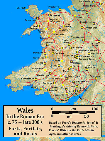
Roman Wales, c. 48 — c. 395: Military Forts, Fortlets, and Roads |
| Date |
12 September 2010 |
| Source |
Based on Frere's Britannia, Jones' & Mattingly's Atlas of Roman Britain, Davies' Wales in the Early Middle Ages, the Antonine Itinerary, and other sources (roads are incomplete; forts were built/abandoned over time) — sources are cited in the image legend
The topographical map is from a sub-region of File:Uk topo en.jpg, with the copyright notice {{Bild-GFDL-GMT|migration=relicense}} and original date of 7 July 2006, copy made in 2008, with the annotations removed by myself. |
| Author |
my work |
Permission
( Reusing this file) |
(see below)
|
|
I, the copyright holder of this work, hereby publish it under the following license:
|
File usage
The following pages on Schools Wikipedia link to this image (list may be incomplete):
You can learn about nearly 6,000 different topics on Schools Wikipedia. SOS Children is famous for the love and shelter it brings to lone children, but we also support families in the areas around our Children's Villages, helping those who need us the most. If you'd like to help, why not learn how to sponsor a child?


