
File:Death Valley NP master map.png
Size of this preview: 437 × 480 pixels.
| |
This is a file from the Wikimedia Commons. Information from its description page there is shown below.
Commons is a freely licensed media file repository. You can help. |
Summary
| Description |
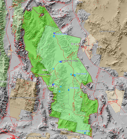
English: Map of the Death Valley National Park showing surrounding area and the previous smaller extent of the Park. Red dots are mine sites, blue triangles are camp sites, and blue question marks are tourist information facilities. This map also shows the old borders of Death Valley National Monument and the new borders of the expanded national park.
Français : Carte du parc et de ses environs.
Magyar: A nemzeti park térképe.
עברית: מפת הפארק הלאומי עמק המוות.
Български: В зелено са отбелязани границите на днешната Долина на смъртта.
|
||||||
| Date | |||||||
| Source | Map created by Daniel Mayer using data from the National Park Service metadata | ||||||
| Author | user:maveric149 (Daniel Mayer) | ||||||
| Permission ( Reusing this file) |
|
File usage
The following pages on Schools Wikipedia link to this image (list may be incomplete):
More information
Schools Wikipedia has made the best of Wikipedia available to students. SOS Children works in 133 countries and territories across the globe, helps more than 62,000 children, and reaches over 2 million people in total. Try to find out how you can help children in other countries on our web site.