
File:Mount St Helens Summit Pano II.jpg
Size of this preview: 640 × 122 pixels.
| |
This is a file from the Wikimedia Commons. Information from its description page there is shown below.
Commons is a freely licensed media file repository. You can help. |
| |
This is a featured picture, which means that members of the community have identified it as one of the finest images on the English Wikipedia, adding significantly to its accompanying article. If you have a different image of similar quality, be sure to upload it using the proper free license tag, add it to a relevant article, and nominate it. |
| |
This image was selected as picture of the day on the English Wikipedia for April 10, 2013. |
|
Warning |
Some browsers may have trouble displaying this image at full resolution: This image has a large number of pixels and may either not load properly or cause your browser to freeze. | Interactive large-image-viewer ( non-Flash) |
|---|
Summary
| Description |
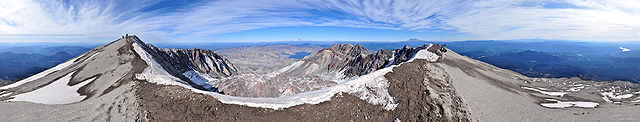
English: 360° panorama from the summit of Mount St. Helens as seen on an early-October afternoon. In the foreground is the ice-covered crater rim. Visible in the lower center is the lava dome. Steam rises from several dome vents. Above the dome, in the upper centre, lies Mount Rainier and Spirit Lake. Mount Adams appears to the right of Rainier on the horizon as well as Mount Hood and Mount Jefferson on the far right. Also on the far right are glimpses of the Swift Reservoir, Yale Lake, Lake Merwin and the Lewis River. Climbers stand on the crater rim and are visible along the Monitor Ridge climbing route. Photo by Gregg M. Erickson
Français : Vue panoramique à 360° depuis le sommet du Mont Saint Helens, dans l'état de Washington, aux États-Unis d'Amérique, par un après-midi de mi-octobre. Au premier plan, on voit le bord du cratère recouvert de glace. Près du centre de l'image se trouve le dôme de lave. De la vapeur d'eau s’échappe de plusieurs bouches du dôme. Au-dessus le dôme, se tiennent le Mont Rainier et le Lac Spirit. Le Mont Adams apparait à la droite du Mont Rainer, sur l'horizon, avec le Mount Hood et le Mont Jefferson, tout à fait à droite. Également à droite, on entrevoit le réservoir Swift, le lac Yale, le lac Merwin et la rivière Lewis. Les alpinistes se tiennent sur le bord du cratère et sont visible près du chemin d’ascension Monitor Ridge. Photo de Gregg M. Erickson.
|
| Date | 11 October 2009, 14:09:58 |
| Source | Own work |
| Author | Farwestern Photo by Gregg M. Erickson |
| 360° | View in 360° panoramic viewer |
|---|
Assessment
|
 |
This image was selected as picture of the day on Wikimedia Commons for 8 April 2013. It was captioned as follows: English: 360° panorama from the summit of Mount St. Helens as seen on an early-October afternoon.
Deutsch: 360°-Panorama vom Gipfel des Mount St. Helens an einem Nachmittag im frühen Oktober.
English: 360° panorama from the summit of Mount St. Helens as seen on an early-October afternoon.
Français : Vue panoramique à 360° depuis le sommet du Mont Saint Helens, par une après-midi de mi-octobre.
Magyar: 360°-os panorámafotó a Mount Saint Helens csúcsáról
Italiano: Panorama a 360° dalla cima del Monte Sant'Elena in un pomeriggio di inizio ottobre.
한국어: 10월 초 오후에 세인트헬렌스 산 정상에서 촬영한 360도 파노라마.
Nederlands: Een panorama van 360 graden vanaf de top van de Mount Saint Helens in de Verenigde Staten op een oktobermiddag.
Русский: Круговая панорама с вершины вулкана Сент-Хеленс октябрьским утром. Штат Вашингтон, США.
中文(简体): 360°全景 圣海伦山山顶全景,拍摄于10月初的一个下午。
|
Licensing
|
File usage
The following pages on Schools Wikipedia link to this image (list may be incomplete):
Metadata
Wikipedia for Schools...
Wikipedia for Schools is one of SOS Childrens Villages' many educational projects. SOS Children works in 133 countries and territories across the globe, helps more than 62,000 children, and reaches over 2 million people in total. Why not try to find out more about sponsoring a child?
Categories: