|
This is a file from the Wikimedia Commons. Information from its description page there is shown below.
Commons is a freely licensed media file repository. You can help.
|
Summary
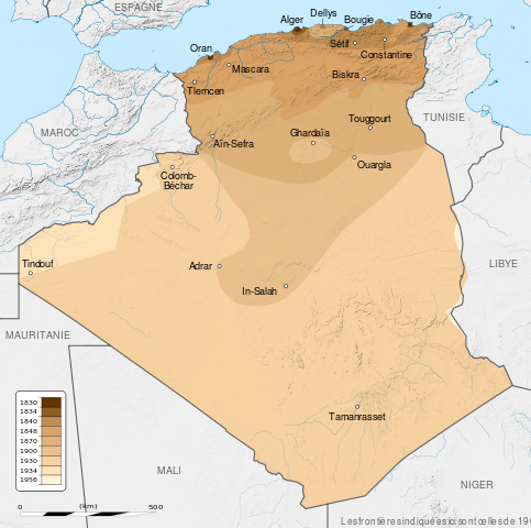
| DescriptionFrench Algeria evolution 1830-1962 map-fr.svg |
English: French Algeria evolution map, from 1830 to 1962.
- Scale: 1:6,800,000 (precision: 1,700 m)
- Equirectangular projection
- WGS84 datum
- Central meridian: 001° 39' E
- Standard parallel: 27° 31' 30" N
- Geographic limits of the map:
- Top: 37° 48' N
- Bottom: 18° 15' N
- Left: 009° 27' W
- Right: 012° 45' E
Français: Carte montrant l'évolution territoriale de l' Algérie française, de 1830 à 1962.
- Échelle : 1:6,800,000 (précision: 1,700 m)
- Projection : équirectangulaire
- Système géodésique : WGS84
- Méridien de référence : 001° 39' E
- Parallèle de référence : 27° 31' 30" N
- Limites de la carte :
- haut : 37° 48' N
- bas : 18° 15' N
- gauche : 009° 27' O
- droite : 012° 45' E
|
| Date |
2012-09-29 18:09 (UTC) |
| Source |
English:
- Background: File:Algeria_location_map.svg
- NGDC World Data Bank II (public domain)
- NGDC GSHHS
- Relief: NASA Shuttle Radar Topography Mission (SRTM3 v.2) (public domain)
- Reference for the boundaries: SGIIAR (Système de Gestion Intégré de l'Information Agricole et Rurale of Algeria).
- Evolution:
- 1830-1930: File:Algérie 1830-1930.JPG
- 1830-1857: Henri Blet (1946) Histoire de la colonisation française : Les étapes d'une renaissance coloniale, 1789-1870, 2, Paris: Arthaud, pp. 136-137
- 1830-1930: Xavier Yacono (1993) Histoire de l'Algérie de la fin de la Régence turque à l'insurrection de 1954, Paris: Éditions de l'Atlanthrope, p. 262 ISBN: 2-86442-032-6.
- 1830-1930: Commandant P. Pollacchi (1930) Les progrès de la pacification française, Collection du Comité Métropolitain du Centenaire de l'Algérie
- 1956: File:Algeria-Libya boundary.jpg
Français:
- Fond de carte : File:Algeria_location_map.svg
- NGDC World Data Bank II (domaine public)
- NGDC GSHHS
- Relief : NASA Shuttle Radar Topography Mission (SRTM3 v.2) (domaine public)
- Référence pour les frontières : SGIIAR (Système de Gestion Intégré de l'Information Agricole et Rurale d'Algérie).
- Évolution:
- 1830-1930: File:Algérie 1830-1930.JPG
- 1830-1857: Henri Blet (1946) Histoire de la colonisation française : Les étapes d'une renaissance coloniale, 1789-1870, 2, Paris: Arthaud, pp. 136-137
- 1830-1930: Xavier Yacono (1993) Histoire de l'Algérie de la fin de la Régence turque à l'insurrection de 1954, Paris: Éditions de l'Atlanthrope, p. 262 ISBN: 2-86442-032-6.
- 1830-1930: Commandant P. Pollacchi (1930) Les progrès de la pacification française, Collection du Comité Métropolitain du Centenaire de l'Algérie
- 1956: File:Algeria-Libya boundary.jpg
|
| Author |
Sémhur |
Attribution
( required by the license) |
© Sémhur / Wikimedia Commons / CC-BY-SA-3.0 (or Free Art License) |
|
Camera location
|
28° 19′ 0.12″ N, 1° 39′ 0.00″ E
|
View this and other nearby images on: Google Maps - Google Earth - OpenStreetMap |
( Info)28.3167;1.65 |
 ✓ The source code of this SVG is valid.
|
|
This vector image was created with Inkscape. This SVG is stored in Inkscape SVG, using some additional features. Please see Help:Inkscape in advance of editing it with other software. |
 |
This SVG file uses embedded text that can be easily translated into your language using this automated tool. Learn more. You can also download it and translate it manually using a text editor.
|
This map was improved or created by the Wikigraphists of the Graphic Lab (fr). You can propose images to clean up, improve, create or translate as well.
বাংলা | català | česky | Deutsch | Deutsch (Sie-Form) | Ελληνικά | English | Esperanto | español | suomi | français | עברית | magyar | Հայերեն | italiano | 한국어 | македонски | Bahasa Melayu | Plattdüütsch | Nederlands | occitan | polski | português | română | русский | slovenščina | svenska | татарча/tatarça | Türkçe | українська | 中文 | 中文(简体) | 中文(繁體) | Zazaki | +/−
Licensing
I, the copyright holder of this work, hereby publish it under the following licenses:
 |
Copyleft: This work of art is free; you can redistribute it and/or modify it according to terms of the Free Art License. You will find a specimen of this license on the Copyleft Attitude site as well as on other sites. http://artlibre.org/licence/lal/enFALFree Art Licensefalsetrue |
You may select the license of your choice.
|
File usage
The following pages on Schools Wikipedia link to this image (list may be incomplete):
This file contains additional information, probably added from the digital camera or scanner used to create or digitize it. If the file has been modified from its original state, some details may not fully reflect the modified file.
SOS Children has brought Wikipedia to the classroom. SOS Children's Villages helps more than 2 million people across 133 countries around the world. Have you thought about sponsoring a child?