
File:NHC Atlantic Forecast Error Trends.png
Size of this preview: 611 × 480 pixels.
| |
This is a file from the Wikimedia Commons. Information from its description page there is shown below.
Commons is a freely licensed media file repository. You can help. |
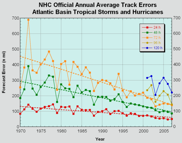
| Description | Error on the track since 1970 in Nautical miles. The different lines represent the forecasted position at different times prior to the verification (ex. 36h means the forecast made 36 h before the verification). |
| Date | 03:21, 28 January 2008 (UTC) |
| Source | NOAA from National Hurricane Centre Forecast Verification |
| Author | National Hurricane Centre |
 |
This graph image could be recreated using vector graphics as an SVG file. This has several advantages; see Commons:Media for cleanup for more information. If an SVG form of this image is already available, please upload it. After uploading an SVG, replace this template with {{ vector version available|new image name.svg}}. |
 |
This image is in the public domain because it contains materials that originally came from the U.S. National Oceanic and Atmospheric Administration, taken or made as part of an employee's official duties.
|
 |
File usage
The following pages on Schools Wikipedia link to this image (list may be incomplete):
Schools Wikipedia and SOS Children
All five editions of Schools Wikipedia were compiled by SOS Children. SOS Childrens Villages helps those who have nothing and no one, giving them back the famly they have lost and bringing them the very best opportunities for a happy, healthy future. Help another child by taking out a sponsorship.