
File:Enso elnino.png
Enso_elnino.png (608 × 413 pixels, file size: 17 KB, MIME type: image/png)
| |
This is a file from the Wikimedia Commons. Information from its description page there is shown below.
Commons is a freely licensed media file repository. You can help. |
Summary
it's under PD-USGov-DOC-NOAA. EN WP says:
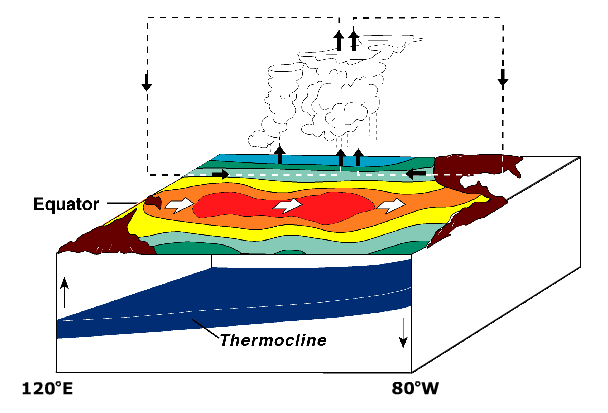
ENSO/ El Niño state.
- Sea surface is warm in central and eastern Pacific.
- Less cold water is pulled up along west coast of South America.
- Hot air rises in central Pacific, travels east and west before cooling and descending.
Derived from NOAA / PMEL / TAO diagrams. http://www.pmel.noaa.gov/tao/proj_over/diagrams/index.html
 |
This diagram image could be recreated using vector graphics as an SVG file. This has several advantages; see Commons:Media for cleanup for more information. If an SVG form of this image is already available, please upload it. After uploading an SVG, replace this template with {{ vector version available|new image name.svg}}. |
Licensing
 |
This image is in the public domain because it contains materials that originally came from the U.S. National Oceanic and Atmospheric Administration, taken or made as part of an employee's official duties.
|
 |
File usage
The following pages on Schools Wikipedia link to this image (list may be incomplete):
Schools Wikipedia facts
Schools Wikipedia was launched to make learning available to everyone. SOS Children is an international children's charity, providing a good home and loving family to thousands of children who have lost their parents. We also work with communities to help vulnerable families stay together and raise children in the best possible environment. There are many ways to help with SOS Children's Villages.