
File:122 - Toronto - Septembre 2009.jpg
| |
This is a file from the Wikimedia Commons. Information from its description page there is shown below.
Commons is a freely licensed media file repository. You can help. |
Summary
|
Warning |
Some browsers may have trouble displaying this image at full resolution: This image has a large number of pixels and may either not load properly or cause your browser to freeze. | Interactive large-image-viewer ( non-Flash) |
|---|
|
 |
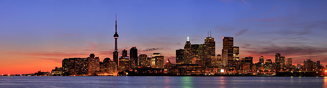
This image was selected as picture of the day on Wikimedia Commons for 7 June 2010. It was captioned as follows: English: Panorama of Toronto
Беларуская (тарашкевіца): Панарама вечаровага Таронта.
Català: Imatge panoràmica de Toronto
Česky: Panorama Toronta ( Kanada)
Dansk: Panorama over Toronto i Canada.
Deutsch: Panorama von Toronto, Kanada
English: Panorama of Toronto
Español: Panorámica de Toronto (Canadá).
Suomi: Panoraamakuva Toronton kaupungista.
Français : Image panoramique de Toronto, à l'aube.
Magyar: Toronto panorámaképe
Հայերեն: Տորոնտոյի համայնապատկերը
Italiano: Un panorama di Toronto, al tramonto. La skyline della città canadese è caratterizzata dalla CN Tower (a sinistra nella foto) che con i suoi 553 m. di altezza, rappresenta la più alta torre per telecomunicazioni del mondo
日本語: トロントのパノラマ
한국어: 토론토의 전경.
Lietuvių: Toronto panorama, Kanada.
Македонски: Панорама на Торонто
Malti: Dehra ta' Toronto, fi nżul ix-xemx. L-iskyline tal-belt Kanadiża hi maħkuma mis- CN Tower (fuq ix-xellug tal-fotografija) li hu għoli 553 m., l-ogħla torri għat-telekomunikazzjoni fid-dinja.
Nederlands: Panorama van Toronto bij zonsopgang. De skyline van deze stad wordt gedomineerd door de CN Tower (Canadian National Tower; links op de foto) die met een hoogte van 553 meter de op een na hoogste tv-toren ter wereld (na de Canton TV Tower in de Chinese stad Guangzhou) en het belangrijkste oriëntatiepunt van de stad vormt.
Polski: Panorama Toronto (Kanada)
Português: Panorama de Toronto
Русский: Панорама Торонто
Українська: Панорама Торонто, вересень 2009 р. (Зображення створено з 27 світлин).
Tiếng Việt: Ảnh chân trời của Toronto
中文(简体): 多伦多全景
中文(繁體): 多倫多全景
|
| Description |
English: Panorama of Toronto.
Français : Image panoramique de Toronto.
Italiano: Un panorama di Toronto, al tramonto. Nella skyline si nota la CN Tower, la più alta torre per telecomunicazioni del mondo.
Türkçe: Toronto, Kanada'nın en büyük şehri ve ticaret merkezi, Ontario eyâletinin başkentidir. Dünyanın en büyük hayvanat bahçelerinden Toronto Zoo şehrin doğusundadır. Güneyinde ise Ontario Gölü vardır.
|
||
| Date | 12 September 2009 | ||
| Source | Own work | ||
| Author | Martin St-Amant ( S23678) | ||
| Permission ( Reusing this file) |
|
|
Camera location |
|
This and other images at their locations on: Google Maps - Google Earth - OpenStreetMap | ( Info) |
|---|
| Camera Model | Canon EOS 50D |
|---|---|
| Shutter speed | 0,5 – 2 – 8 s |
| Aperture | f 5,6 |
| Film speed (ISO) | 100 |
| Lens | Canon EF-S 17–85mm IS USM |
| Focal length | 72mm |
| Notes | Ce panorama est composé de / This panorama is composed of : 27 images Français : Les images ont été assemblées par Hugin à l'aide d'Enblend et Enfuse.
English: The images were assembled with Hugin.
Türkçe: Toronto, Kanada'nın en büyük şehri ve ticaret merkezi, Ontario eyâletinin başkentidir. Dünyanın en büyük hayvanat bahçelerinden Toronto Zoo şehrin doğusundadır. Güneyinde ise Ontario Gölü vardır.
|
Licensing
|
File usage
Metadata
Schools Wikipedia facts
Through Schools Wikipedia, SOS Children has brought learning to children around the world. SOS Childrens Villages believes education is an important part of a child's life. That's why we ensure they receive nursery care as well as high-quality primary and secondary education. When they leave school, we support the children in our care as they progress to vocational training or higher education. Help another child by taking out a sponsorship.